Final Program
The Registration Desk will be open at the following times:
- August 31: 16:30 – 20:00
- September 1: 08:15 – 19:00
- September 2: 08:15 – 19:00
- September 3: 08:15 – 17:30
- September 4: 08:15 – 19:00
- September 5: 08:15 – 17:00
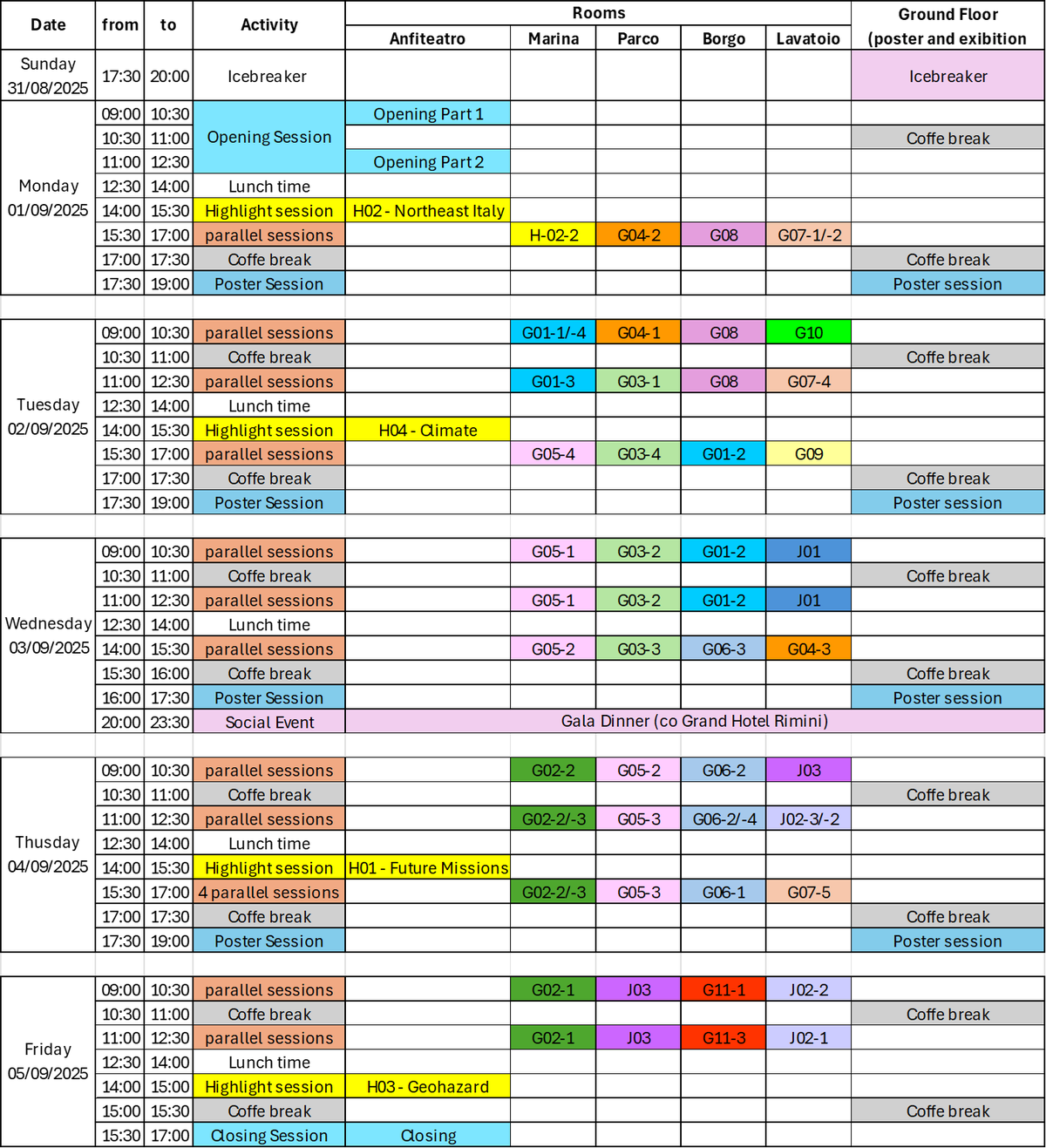
Detailed Daily Program
Monday Sept. 1, 2025
Morning
Opening Session(Anfiteatro room)
| 09:00 – 09:15 | Opening of the IAG Scientific Assembly 2025 |
| Richard Gross (IAG President) | |
| 09:15 – 09:25 | Welcome by IUGG: IUGG perspective on IAG |
| Chris Rizos (IUGG President) | |
| 09:25 – 09:30 | Welcome by city of Rimini |
| Councilor, Prof.ssa Anna Montini (Delegate for Ecological Transition, Blue Economy and Statistics of the Municipality of Rimini) | |
| 09:30 – 09:35 | Welcome by University Bologna |
| Prof. Andrea Cimatti (Head of Physics and Astronomy Department, University of Bologna) | |
| 09:35 – 09:40 | Welcome address by LOC |
| Prof. Susanna Zerbini, Co-chair of LOC (Alma Mater Professor, Physics and Astronomy Department, University of Bologna) | |
| 09:40 – 09:55 | Introduction to IAG Symposia organization |
| Daniela Thaller (IAG Secretary General, Chair of SOC) | |
| 09:55 – 10:00 | JoG Young Author Award 2023:Safoora Zaminpardaz |
| Award presented by Richard Gross and Daniela Thaller | |
| 10:00 – 10:20 | JoG Young Author Award 2024: Justyna Śliwińska |
| Presentation by Justyna Śliwińska | |
| Award presented by Richard Gross and Daniela Thaller | |
| 10:20 – 10:25 | Best reviewer Award 2023: Bailing Li |
| Award presented by Richard Gross and Daniela Thaller | |
| 10:25 – 10:30 | Best reviewer Award 2024: Judit Benedek |
| Award presented by Richard Gross and Daniela Thaller | |
| Coffee break | |
| 11:00 – 11:05 | Introduction to part 2 |
| Richard Gross | |
| 11:05 – 11:25 | Presentation by Sponsor ESA |
| ESA's geodetic missions: past, present and future | |
| Dr. Ilias Daras (ESA) | |
| 11:25 – 11:45 | Presentation by Sponsor ENI |
| Geodesy and Eni:an untarnished common evolution pathway | |
| Dr. Davide Calcagni (ENI - Senior Advisor to Exploration Director Technology and Industrial Scouting) | |
| 11:45 – 12:05 | Presentation by Sponsor Unipol |
| Connecting geodesy and insurance for safer communities | |
| Dr. Renzo Giovanni Avesani (Chairman at Leithà, Unipol Group) | |
| 12:05 – 12:25 | Presentation by UN GGCE |
| What does a robust global geodesy supply chain look like? | |
| Liubov Poshyvailo-Strube (on behalf of Nick Brown, Head of the UN-GGCE) | |
| 12:25 – 12:30 | Closing and start scientific program |
| Daniela Thaller |
Afternoon
Highlight Session
H02 - Northeast Italy (Anfiteatro room)
Chairmans: Susanna Zerbini, Stefano Gandolfi
| 14:00 – 14:20 | Astronomical tuning of plate tectonics: a key to understand the northern Adriatic area |
| Carlo Doglioni | |
| 14:20 – 14:40 | Radar interferometry from space for surface displacements investigation: three decades of developments and observations |
| Riccardo Lanari | |
| 14:40 – 15:00 | Long-term variations of mean sea level and extreme events in the northern Adriatic |
| Fabio Raicich | |
| 15:00 – 15:20 | Monitoring and modelling marshland elevation changes along the Po Plain coast. Projecting their fate under climate change and anthropogenic pressure |
| Pietro Teatini, Marta Cosma, Cristina Da Lio, Anna Maria Mazzia, Urooj Qayyum, Luigi Tosi and Claudia Zoccarato |
Parallel Sessions
Marina room - H02-02 - Northeast Italy
Chairmans: Susanna Zerbini, Stefano Gandolfi
| 15:30 – 15:45 | Geodynamical monitoring in Italian CCS projects |
| M. C. Dacome, G. Dell’elce, F. Pedrazzi, A. Pozzoli, M. Vettorel | |
| 15:45 – 16:00 | Drought-induced vertical displacements and water loss in the Po river basin (Northern Italy) from GNSS measurements |
| Francesco Pintori and Enrico Serpelloni | |
| 16:00 – 16:15 | Four Decades of shoreline evolution in the Emilia-Romagna region under anthropogenic influence |
| Enrica Vecchi, Matteo Meli and Claudia Romagnoli | |
| 16:15 – 16:30 | LiDAR-driven topographic surveys for floodplain management in Northern Marche |
| Eva Savina Malinverni, Francesco Di Stefano, Marsia Sanità, Stefano Chiappini and Alberto Tazioli | |
| 16:30 – 16:45 | DInSAR displacements calibration with GNSS measurements in subsiding areas: the Emilia-Romagna (Italy) case study |
| Eugenia Giorgini, Manuela Bonano, Claudio De Luca, Giovanni Onorato, Ricardo Lanari and Stefano Gandolfi | |
| 16:45 – 17:00 | GIN Project, a Geodetic Integrated Network for monitoring and topographical survey on the Emilia-Romagna Region suitable both for classical and space geodetic techniques. |
| Nunzio De Nigris, Michele Di Lorenzo, Stefano Gandolfi, Marco Marcaccio, Stefano Olivucci, Alberto Pellegrinelli, Luca Tavasci, Andrea Valentini and Enrica Vecchi |
Parco Room - G04 Earth Rotation and Geodynamics
G04-2: Tidal and non-tidal mass signatures in space and surface geodetic observations
Chairmans: Carla Braitenberg, Henryk Dobslaw, Severine Rosat, Xiaoming Cui
| 15:30 – 15:45 | Tides of the Moon |
| Xiaodong Chen, Binbin Liao, Heping Sun and Mingqiang Hou | |
| 15:45 – 16:00 | The excitation of atmospheric tide on the Celestial Pole Offsets |
| Xiaoming Cui, Weiwei Yang and Heping Sun | |
| 16:00 – 16:15 | Accurate tidal and non-tidal reductions of gravity records for volcano monitoring: the Campi Flegrei Superconducting gravity station |
| Raffaella Casolaro, Umberto Riccardi, Tommaso Pivetta, Stefano Carlino, Jacques Hinderer and Federic Littel | |
| 16:15 – 16:30 | Comparative analysis of geocenter motion estimation using GNSS data: Network Shift vs. Surface Load Displacement approaches |
| Adrian Nowak, Radosław Zajdel and Krzysztof Sośnica | |
| 16:30 – 16:45 | Mitigating Non-Tidal Loading Effects in Raw Observation-Level GNSS Time Series: Case Studies from Antarctic and Beyond |
| Yohannes Getachew Ejigu, Hannu Koivula, Jyri Näränen, Arttu Raja-Halli, Fatemeh Khorrami and Maaria Nordman | |
| 16:45 – 17:00 | Double-difference and precise point positioning processing strategies to determine OTL effect in GNSS time series |
| Anna Fantoni, Carla Braitenberg, Roberto Devoti and Grazia Pietrantonio |
Borgo Room - G08 Geodesy for Climate Research
G08-1: Geodesy for Climate Research
Chairmans: Annette Eicker, Balaji Devaraju, Carmen Blackwood, Frank Ghomsi, Maria Fernanda Camisay
| 15:30 – 15:45 | New ZTD SIRGAS products, from homogenization on IGS14, adjustments to the combination strategy, and north American stations inclusion |
| Maria Virginia Mackern Oberti, Patricia Alejandra Rosell, Maria Laura Mateo and Maria Fernanda Camisay | |
| 15:45 – 16:00 | Consistency and Homogeneity of ZTD Estimates from IGS Repro3 |
| Hugo Breton, Bock Olivier, Samuel Nahmani and Pierre Bosser | |
| 16:00 – 16:15 | Advancing Climate Research through GNSS Reflectometry: A Novel Geodetic Approach to Monitoring Earth System Processes |
| Milad Asgarimehr, Tianqi Xiao, Daixin Zhao, Hamed Izadgoshasb and Jens Wickert | |
| 16:15 – 16:30 | First quasi-global soil moisture retrieval using Fengyun-3 GNSS-R constellation observations |
| Wentao Yang, Fei Guo and Xiaohong Zhang | |
| 16:30 – 16:45 | Intense Mesoscale Convective Systems in Central Africa and associated large scale environments |
| Vanessa S. Ngono Ashu | |
| 16:45 – 17:00 | Geodesy for Climate Actions |
| C K Shum, Yu Zhang, Shengdao Wang, Patrick Smith, Yixin Xiao, Yang Tang, Metehan Uz, Kazim Atman, Orhan Akyilmaz, Ehsan Forootan, Jean-Philippe Montillet, Jérôme Benveniste and Erick Lansard |
Lavatoio Room - G07 ICCT – Advances in geodetic theory
G07-1: Gravitational field modelling and analysis for the Earth and for oblate and prolate planetary bodies and irregularly shaped celestial bodies
Chairmans: Dimitrios Tsoulis, Michal Šprlák, Zhi Yin, Ropesh Goyal, Sten Claessens
| 15:30 – 15:45 | Far-Zone Effects for Spherical Integral Transformations |
| Michal Šprlák, Martin Pitoňák, Jiří Belinger, Petr Trnka and Pavel Novák | |
| 15:45 – 16:00 | Gravity degree-depth relations for high-order disturbing potential gradients |
| Xiao-Le Deng, Nico Sneeuw and Dimitrios Tsoulis | |
| 16:00 – 16:15 | When in doubt smooth! Returning to the convergence problem in collocation theory |
| Fernando Sansò and Giovanna Venuti |
G07-2: Geoid/quasigeoid modelling approaches in view of cm-precision/cm-accuracy
Chairmans: Dimitrios Tsoulis, Michal Šprlák, Zhi Yin, Ropesh Goyal, Sten Claessens
| 16:15 – 16:30 | Integration Studies of webGIS and VR Technologies in Modeling the Gravity Fields of Solar-System Bodies |
| Zhi Yin, Kefei Zhang, Junsheng Liu, Qinglu Mu, Yabo Duan and Jingsheng Zhang | |
| 16:30 – 16:45 | Consistent determination of the gravimetric geoid and orthometric height |
| Pavel Novák and Robert Tenzer | |
| 16:45 – 17:00 | A conceptualisation of a consistently precise and accurate centimetre geoid |
| Ropesh Goyal and Sten Claessens |
17:30 - 19:00 Poster Session
___________________________________________________________________________________
Tuesday Sept. 2, 2025
Morning
Parallel Sessions
Marina Room - G01 Reference Frames
G01-1: Space Techniques: Prerequisites for current and future terrestrial and lunar missions
Chairmans: Krzysztof Sosnica, Maria Karbon
| 09:00 – 09:15 | GENESIS-D: Contribution from German organizations to ESA’s GENESIS Mission |
| Harald Schuh, Robert Heinkelmann, Mathis Bloßfeld, Frank Flechtner, Claudia Flohrer, Susanne Glaser, Benjamin Männel, Patrick Schreiner, Florian Seitz, Manuela Seitz and Daniela Thaller | |
| 09:15 – 09:30 | SLR-Based Reference Frame Employing LAGEOS and Sentinel-6A |
| Kyriakos Balidakis, Luca Weinem, Claudia Flohrer, Alexander Kehm, Daniel Koenig, Daniela Thaller, William Desprats, Ulrich Meyer, Mathis Blossfeld, Daniel Arnold and Linda Geisser | |
| 09:30 – 09:45 | The Surface-Fixed Lunar Reference Frame |
| Brent Archinal, Al Conrad, Tom Duxbury, Daniel Hestroffer, James Hilton, Laurent Jorda, Randy Kirk, Sergei Klioner, Jean-Luc Margot, David Mayer, Jürgen Oberst, Flora Paganelli, Ryan Park, Jinsong Ping, P. Kenneth Seidelmann, Alex Stark, David Tholen and Iwan Williams | |
| 09:45 – 10:00 | Report from the IAG JWG 1.1.3 about Lunar reference frames |
| Agnès Fienga, Krzysztof Sosnica, Kayla J. Brinkley, Pascale Defraigne, Trevor W. Garner, Cheryl Gramling, Robert Heinkelmann, Luciano Iess, Maria Karbon, Sergei Klioner, Erwan Mazarico, Stephen Merkowitz, Masaya Murata, Jurgen Müller, Flora Paganelli, Dmitry Pavlov, Jinsong Ping, Nicolas Rambaux, Susan Stewart, Richard Swiden and Javier Ventura-Traveset |
G01-4: The International Celestial Reference Frame for Geodetic Applications: Requirements, Challenges, and Future Prospects
Chairmans: Krzysztof Sosnica, Maria Karbon
| 10:00 – 10:15 | Linking Planetary Ephemeris Reference Frames to ICRF via Millisecond Pulsars |
| Li Guo, Yueqi Song and Zhen Yan | |
| 10:15 – 10:30 | Detection of a Systematic Parallax Effect in VLBI Observations |
| Angelina Osetrova and Oleg Titov |
Parco Room - G04 Earth Rotation and Geodynamics
G04-1 : Geodetic Constraints and Modeling of Glacial Isostatic Adjustment and Cryospheric Deformation Across Time Scales
Chairmans: Carsten Ludwigsen, Ingo Sasgen, Karen Simon, Lambert Caron, Matthias Willen
| 09:00 – 09:15 | A New Generation of Land Uplift and Glacial Isostatic Adjustment Models for Northern Europe |
| Holger Steffen, Jonas Ågren, Andrzej Araszkiewicz, Tobias Arnell, Valentina R. Barletta, Michael Dähnn, Pasi Häkli, Pingping Huang, Lotti Jivall, Halfdan P. Kierulf, Tong Ning, Maaria Nordman, Matthew Simpson, Rebekka Steffen, Lev Tarasov, Olav Vestøl, Vents Zuševic and The Nkg Gnss Analysis Centre | |
| 09:15 – 09:30 | Strain rate evolution in the European Alps due to Glacial Isostatic Adjustment since the Last Glacial Maximum |
| Fernando Linsalata, Daniele Melini and Giorgio Spada | |
| 09:30 – 09:45 | Long-term variations in the Earth’s Figure axis and polar motion |
| Minkang Cheng |
G04-4 : Open Session on Earth Rotation and Geodynamics
Chairmans: Carsten Ludwigsen, Ingo Sasgen, Karen Simon, Lambert Caron, Matthias Willen
| 09:45 – 10:00 | Real-Time High-Frequency Estimation of Earth Rotation Parameters Using Global Navigation Satellite Systems (GNSS) |
| Zhiwei Qin, Shuli Song, Jungang Wang, Qinming Chen, Maorong Ge | |
| 10:00 – 10:15 | Interannual oscillations in length of day changes and relations with ENSO and climate indices |
| M. Wińska, D. Staniszewska, J. Śliwińska-Bronowicz, J. Nastula | |
| 10:15 – 10:30 | Opportunities of earth rotation sensing with large area optical time and frequency transfer network |
| Bin Wang, Yize Zhang, Weijie Tan, Junping Chen, Kexin Xu, Chenglong Zhang, Xing Su |
Borgo Room - G08 Geodesy for Climate Research
G08-1: Geodesy for Climate Research
Chairmans: Annette Eicker, Balaji Devaraju, Carmen Blackwood, Frank Ghomsi, Maria Fernanda Camisay
| 09:00 – 09:15 | European daily GPS-observed displacements for hydrogeodesy |
| Anna Klos, Anne Springer, Artur Lenczuk, Jan Mikocki, Christian Mielke, Juergen Kusche and Janusz Bogusz | |
| 09:15 – 09:30 | High-resolution terrestrial water storage estimates derived from integrated GPS and InSAR displacements: the Seine case study |
| Jan Mikocki, Anna Klos, Susanna Werth, Artur Lenczuk and Janusz Bogusz | |
| 09:30 – 09:45 | Simultaneous Estimation of Present-Day Surface Mass Trend, Ice History and Earth Rheology from Space Geodetic and Historical Data WITHDRAWN |
| Xiaoping Wu, Giorgio Spada, Daniele Melini and Yan Jiang WITHDRAWN | |
| 09:30 – 09:45 | Potential of current and future satellite gravity missions for the evaluation of extreme events in global coupled climate models |
| Klara Middendorf, Marius Schlaak, Roland Pail, Laura Jensen, Henryk Dobslaw and Annette Eicker | |
| 09:45 – 10:00 | Transboundary groundwater monitoring based on in-situ observations and downscaled GRACE/GRACE-FO estimates: A case study of the Bug River Basin |
| Justyna Śliwińska-Bronowicz, Tatiana Solovey, Rafał Janica, Agnieszka Brzezińska and Anna Stradczuk | |
| 10:00 – 10:15 | AAU’s approach for assimilating current and future satellite gravity data into high resolution global hydrological models |
| Ehsan Forootan, Fan Yang, Leire Retegui-Schiettekatte, Marius Schlaak, Roland Pail and Maike Schumacher | |
| 10:15 – 10:30 | GRACE mass change solutions for sea-level budget assessments: methods, results, and uncertainties |
| Thorben Döhne, Martin Horwath and Marie Bouih |
Lavatoio Room - G10-1: Modern Concepts and Quantum Technology for Geodesy
Chairmans: Jakob Flury, Jürgen Müller, Marcelo Santos, Marvin Reich, Öykü Koç
| 09:00 – 09:15 | Chronometric levelling with transportable optical clocks |
| Christian Lisdat (solicited) | |
| 09:15 – 09:30 | Centimeter-level global height system unification using spatial bi-directional optical frequency links via satellite |
| Ziyu Shen, Pengfei Zhang, An Ning and Wenbin Shen | |
| 09:30 – 09:45 | ELT: An optical time transfer method based on SLR and one-way ranging |
| Anja Schlicht, Stefan Marz, Jan Kodet, Johann Eckl, Ulrich Schreiber, Ivan Prochazka, Josef Blazej, Achim Helm, Shuo Liu, Theo Schwall, Wolfgang Schaefer, Luigi Cacciapuoti and Christoph Salomon | |
| 09:45 – 10:00 | Simulation of Frequency Differences between Earth- and Moon-bound Clocks |
| Mingyue Zhang and Jürgen Müller | |
| 10:00 – 10:15 | How accurately can an optical clock network estimate absolute gravity potential? |
| Miltiadis Chatzinikos and Pacome Delva | |
| 10:15 – 10:30 | European QUantum Infrastructure Project for Gravimetry |
| Sébastien Merlet, Przemyslaw Dykowski, Daniele Carbone, Lucia Seoane and Marvin Reich |
Coffe Break
Parallel Sessions
Marina Room - G01 Reference Frames
G01-3: Regional Reference Frames: Status, Challenges and Applications
Chairman: Fernand Bale
| 11:00 – 11:15 | A concept for transition from Static to a Temporal Saudi Arabia Saudi Arabia National Spatial Reference System (TSANSRS) |
| Rossen Grebenitcharsky, Sultan Alshahrani, Iurii Golubinka, Elena Rangelova, Uthman Alrubaia and Abdullah Alqahtani | |
| 11:15 – 11:30 | From a global reference frame to regional reference frames, how to handle this for a global GNSS network |
| Francesco Matonti, Joanna Wnuk and Adam Miller. | |
| 11:30 – 11:45 | WG I-SIRGAS: Current strategies for GNSS processing and analysis in the SIRGAS-CON |
| José Antonio Tarrio Mosquera, Catalina Cáceres Venegas, Alberto da Silva, Laura Sánchez, Sonia Alves Costa, Nilton Ribas Júnior, María Virginia Mackern, Julio Teixeira, Karina Rosero, Micaela Carbonetti, Guido González, Tony Aparco, Oscar Rodríguez, Ángel Zapata, Álvaro Álvarez, Mauricio Varela and Hernan Guerra. | |
| 11:45 – 12:00 | Comparative Assessment of Epoch-Wise Realization of a Regional Reference Frame With Conventional and Innovative Approaches Using Indian CORS Sub-Network Observations |
| Ratnesh Kushwaha, Mathis Bloßfeld, Alexander Kehm, Nagarajan Balasubramanian and Onkar Dikshit. | |
| 12:00 – 12:15 | The Asia-Pacific Reference Frame (APREF) project - Learnings from operation over 15 years and the recent progress |
| Guorong Hu, Anna Riddell, Ryan Ruddick and Basara Miyahara. | |
| 12:15 – 12:30 | Do we need to apply Atmospheric tidal and non-tidal loading in the regional GNSS double differencing networks? : Investigation with consistent reprocessing of 27 years of BKG regional network |
| Lin Wang, Axel Rülke, Tetyana Romanyuk and Ole Roggenbuck. |
Parco Room - G03 Gravity Field – Technology and Techniques
G03-1: Next Generation Technologies
Chairmans: David Wiese, Derek van Westrum, Jürgen Müller, Luca Massotti
| 11:00 – 11:15 | Novel Sensors and Quantum Technology for Geodesy (QuGe) |
| Jürgen Müller | |
| 11:15 – 11:30 | Laser Ranging for future Gravity Missions |
| Malte Misfeldt, Vitali Müller, Gerhard Heinzel, Kai Voss and Kolja Nicklaus | |
| 11:30 – 11:45 | Exploring the Prospect of a Constellation of Microsatellites enabled by the Development of DORT, a new Miniaturized Ranging System |
| Matthew Darrow, Roland Pail, Thomas Gruber, Elisabeth Paul and Bastian Eder | |
| 11:45 – 12:00 | SENSORIS – a concept for high-temporal gravity field solutions |
| Matthias Weigelt, Johann Max Rohr, Joshua Reeder, Alexander Koch, Benny Rievers, Tim Gust and Antonio Garcia | |
| 12:00 – 12:15 | Measuring gravity gradients in future missions equipped with quantum sensors |
| João Encarnação, Christian Siemes, Ilias Daras, Olivier Carraz, Aaron Strangfeld, Philipp Zingerle and Roland Pail | |
| 12:15 – 12:30 | Implementation of clock measurements in satellite-based gravity field recovery – A closed-loop feasibility study |
| Moritz Huckfeldt, Florian Wöske and Benny Rievers |
Borgo Room - G08 Geodesy for Climate Research
G08-1: Geodesy for Climate Research
Chairmans Annette Eicker Balaji Devaraju Carmen Blackwood Frank Ghomsi Maria Fernanda Camisay
| 11:00 – 11:15 | Refining Geodetic Ocean Heat Content Estimates: Improved Leakage Corrections for Gravimetry and associated induced uncertainties in the Ocean Heat Content estimates |
| Hugo Lecomte, Sebastien Fourest, Benoit Meyssignac, Alejandro Blazquez, Julia Pfeffer, Noémie Lalau, Robin Fraudeau, Michael Ablain and Alexandre Boughanemi | |
| 11:15 – 11:30 | Antarctic Sea Level and Steric Sea Level Variation from Observations WITHDRAWN |
| Franck Eitel Kemgang Ghomsi, Jennifer V. Lukovich and Julienne Stroeve WITHDRAWN | |
| 11:15 – 11:30 | Closed-loop Simulations of Current and Future Satellite Gravity Missions — a Parameter Model Comparison for Retrieving the Long-term Trend |
| Marius Schlaak and Roland Pail | |
| 11:30 – 11:45 | Satellite Geodesy for Assessing Future Sea Level Change Impacts |
| R. Steven Nerem, Ashley Bellas-Manley, Eduard Heijkoop, Martin Kolster and Alexa Putnam | |
| 11:45 – 12:00 | Recoverability of AMOC signal in satellite gravimetry: A closed loop simulation study |
| Linus Shihora, Marius Schlaak, Rory Bingham, Henryk Dobslaw and Roland Pail (presented by Marius Schlaak) | |
| 12:00 – 12:15 | A satellite-driven framework for long-term river discharge assessment |
| Paolo Filippucci and Angelica Tarpanellli | |
| 12:15 – 12:30 | Evaluating Nigerian Transgressive Mud Coast Vulnerability to Coastal Flooding Hazards in a Changing Climate |
| Olusegun Dada |
Lavatoio Room - G07 ICCT – Advances in geodetic theory
G07-4: High-precision GNSS theory and algorithms
Chairman Dimitrios Psychas
| 11:00 – 11:15 | Detection and Identification of Integer Ambiguity-Resolved GNSS Model Biases |
| Peter Teunissen, Chengyu Yin and Christian Tiberius | |
| 11:15 – 11:30 | Extending Geodetic Estimation Theory by Factor Graph Optimization: A Case Study On GNSS PPP |
| Axel Koppert and Eva Buchmayer | |
| 11:30 – 11:45 | Long-term multipath modeling for permanent GNSS stations |
| Yuanxin Pan and Benedikt Soja | |
| 11:45 – 12:00 | Dual mixed-integer least-squares estimation for GNSS baseline-length constrained direction finding |
| Lotfi Massarweh and Peter J.G. Teunissen | |
| 12:00 – 12:15 | Satellite biases estimable in undifferenced and uncombined PPP-RTK: can they serve as OSB-like corrections? |
| Pengyu Hou, Dimitrios Psychas and Baocheng Zhang | |
| 12:15 – 12:30 | Satellite phase bias determination in the presence of ambiguity jumps: theory and PPP-RTK results |
| Dimitrios Psychas, Amir Khodabandeh and Peter J. G. Teunissen |
Afternoon
Highlight Sessions
Anfiteatro Room - H04-1 Geodesy for Climate and Water
Chairmans Annette Eicker Carmen Blackwood Jay Famiglietti
| 14:00-14:25 | Present-day sea level changes: the role of observations |
| Anny Cazenave | |
| 14:25-14:50 | From Geodesy to Forecasting: Employing GNSS Atmospheric Water Vapor Observations for Hurricane Monitoring and Early Warning |
| Yohannes Getachew Ejigu and Maaria Nordman | |
| 14:50-15:15 | Terrestrial Water Storage and Groundwater as Essential Climate Variables |
| Andreas Güntner | |
| 15:15-15:30 | Break to transition to next session |
Parallel Sessions
Marina Room - G05 Advances in GNSS, Positioning Technologies, and Engineering Geodesy
G05-4: Engineering Geodesy
Chairmans Janina Peplinska Janis Kaminskis
| 15:30 – 15:45 | The new Italian LiDAR Digital Surface and Terrain Models and Aerogravimetric Database |
| Silvano Pecora, Maria Paola Bonofiglio, Carlo Doglioni, Giuseppe Poccia, Fernando Sansò, Riccardo Barzaghi, Renè Forsberg, Vittorio Casella, Marco Arciero and Mattia Crespi | |
| 15:45 – 16:00 | Connecting InSAR EGMS Basic time series to ITRF for seismic hazard monitoring: problems and applications |
| Laura Giaccio, Alessandra Maria de Pace, Alexandru Lăpădat, Valeria Belloni, Roberta Ravanelli, Freek van Leijen, Ramon Hanssen and Mattia Crespi | |
| 16:00 – 16:15 | High-Precision Wide-Bandwidth Deformation Monitoring Using Mass-Market GNSS/Accelerometers |
| Guangcai Li, Jianghui Geng, Yongjie Xu and Jacek Paziewski | |
| 16:15 – 16:30 | Comparative Analysis of Point Clouds Acquired by iPhone 15 Pro Max equipped with ViDoc RTK Rover and Leica BLK2GO for Structural Condition Assessment |
| Nicole Pascucci, Laura Marconi, Maria Alicandro, Donatella Dominici and Sara Zollini | |
| 16:30 – 16:45 | Bridge deformation monitoring using low-cost GNSS sensor array |
| Bence Turák, Csaba Égető and Szabolcs Rozsa | |
| 16:45 – 17:00 | A Small Sample Data-Applicable BDS/GNSS Deformation Accurate Prediction Model Considering both Global and Local Features |
| Cheng Hou, Junbo Shi, Chenhao Ouyang, Jiming Guo and Jingui Zou |
Parco Room - G03 Gravity Field – Technology and Techniques
G03-4: Analysis, algorithms, and Models
Chairmans Athina Peidou Khosro Ghobadi-Far Rebecca McGirr Sinem Ince
| 15:30 – 15:45 | CSR GRACE RL07 Processing: Results from Level-2 and Mascon Solutions |
| Himanshu Save, Chaoyang Zhang, Byron Tapley, Srinivas Bettadpur, Nicholas Childress, Nadege Pie, Peter Nagel, Zhigui Kang, Benjamin Krichman, Geethu Jacob, Mark Tamisiea, John Ries and Steven Poole | |
| 15:45 – 16:00 | Spatiotemporal Interpolation of Residual KBR1B Data for High-Frequency Mass Change Models |
| Michal Cuadrat-Grzybowski and Joao Teixeira da Encarnacao | |
| 16:00 – 16:15 | Evaluation and Tuning of Mascon Approach for Temporal Gravity Field Recovery |
| Simon Schiller, Huiyi Wu, Marius Schlaak and Roland Pail. | |
| 16:15 – 16:30 | On the investigation of GRACE-FO LRI post-fit residuals |
| Mathias Frye, Igor Koch and Jakob Flury | |
| 16:30 – 16:45 | Understanding the spectral analysis of data sampled non-uniformly on a circle: Implications for satellite gravimetry |
| Digvijay Singh and Balaji Devaraju | |
| 16:45 – 17:00 | Assimilating terrestrial time-lapse gravimetry data into hydrogeological models to resolve water storage change variations |
| Nazanin Mohammadi, Hamzeh Mohammadigheymasi and Landon Halloran. |
Borgo Room - G01 Reference Frames
G01-2: International Terrestrial Reference Frame: Challenges, future developments and applications
Chairman Mathis Bloßfeld
| 15:30 – 15:45 | ITRF2020 Updates: Motivations, Results and Uncertainty Evaluation |
| Zuheir Altamimi, Paul Rebischung, Xavier Collilieux, Julien Barnéoud, Kristel Chanard and Maylis de la Serve | |
| 15:45 – 16:00 | A comparison of ITRF2020, DTRF2020 and JTRF2020 |
| Paul Rebischung, Julien Barnéoud, Kevin Gobron, Maylis de La Serve, Xavier Collilieux and Zuheir Altamimi | |
| 16:00 – 16:15 | Evaluation of ITRS 2020 realizations and their extensions for POD of altimetry and geodetic satellites |
| Sergei Rudenko, Mathis Bloßfeld, Manuela Seitz and Julian Zeitlhöfler | |
| 16:15 – 16:30 | Intercomparison of ITRF2020 and JTRF2020 solutions at reference frame level |
| Christopher Kotsakis and Miltiadis Chatzinikos | |
| 16:30 – 16:45 | Advancements in Global Terrestrial Reference Frame: A Comprehensive Analysis of GNSS Velocity Fields, Plate Motion Models, geocentric motion and CTRF2023 |
| Hu Wang, Jing Jiao, Yingying Ren, Xinlin Wang and Wei Wang | |
| 16:45 – 17:00 | ESA’s efforts towards a Combination On the Observation Level |
| Erik Schoenemann, Ivan Sermanoukian Molina, Francesco Gini, Tim Springer, Michiel Otten, Florian Dilssner, Volker Mayer, Birgit Traiser, Sara Bruni, Jean-Christophe Berton, Frank Zimmermann, Werner Enderle and Sara Gidlund |
Lavatoio Room - G09-1 Seafloor Geodesy, Marine Positioning and Undersea Navigation
Chairmans Heidrun Kopp Valérie Ballu
| 15:30 – 15:45 | New technologies and operations to resolve the problem of sea surface platforms for GNSS-A |
| Yusuke Yokota | |
| 15:45 – 16:00 | Understanding biases due to the instrumental errors in GNSS-A seafloor positioning |
| Shun-Ichi Watanabe, Tadashi Ishikawa, Yusuke Yokota, Yuto Nakamura and Koya Nagae | |
| 16:00 – 16:15 | Acoustic Array Design and Solutions for Resisting the Sound Speed Variation Effect on the Seafloor Geodesy |
| Shuqiang Xue, Shuang Zhao and Zhen Xiao (树强 薛, 爽 赵 and 圳 肖) | |
| 16:15 – 16:30 | A novel reconstruction method of ocean sound speed field based on U-Net network with application in underwater acoustic positioning |
| Kaifei He and Song Wang | |
| 16:30 – 16:45 | Integrating and testing pressure, inertial and photogrammetry data for seafloor mapping and marine habitat monitoring |
| Fabio Menna, Erica Nocerino, Alessio Calantropio, Alessandro Lambertini, Shahriar Mokhtari, Luca Vittuari, Maria Gabriella Gaeta, Cristiana Bragalli, Silvio Del Pizzo and Salvatore Troisi | |
| 16:45 – 17:00 | Post-seismic viscoelastic deformation of seafloor reference points for nearly 10 years following the 2011 Tohoku-Oki earthquake Mw 9.0 |
| Jie Dong and Shuqiang Xue |
17:30 - 19:00 Poster Session
_________________________________________________________________________________
Wednesday Sept. 3, 2025
Morning
Parallel Sessions
Marina Room - G05 Advances in GNSS, Positioning Technologies, and Engineering Geodesy
G05-1: Emerging Positioning Technologies and GNSS Augmentations
Chairmans Dinesh Manandhar Fabricio S. Prol Heidi Kuusniemi Mahmoud Elsanhoury
| 09:00 – 09:15 | LEO-PNT Receiver Positioning Performance for Dynamic Users: A Hardware-in-the-Loop Evaluation |
| Francesco Menzione, Andrea Piccolo, Domenico Di Grazia and Fabio Pisoni | |
| 09:15 – 09:30 | Optimization of LEO Doppler-smoothed code positioning and velocity estimation |
| Yan Yang, Fei Guo and Xiaohong Zhang | |
| 09:30 – 09:45 | Real-Time LEO Satellite Clock Determination — Progress and Challenges |
| Meifang Wu, Kan Wang, Jinqian Wang, Wei Xie and Jiawei Liu | |
| 09:45 – 10:00 | Advancements in PPP with LEO-PNT Integration: A Study on Convergence Time |
| Marianna Alghisi, Nikolina Zallemi and Ludovico Biagi | |
| 10:00 – 10:15 | A RANSAC-Based GNSS/Inertial/Visual Graph Optimization Algorithm for Complex Urban Environments |
| Runhua Chen, Hua Chen and Weiping Jiang | |
| 10:15 – 10:30 | Collaborative Urban Navigation: Real-World Validation of Multi-Agent Multi-Sensor Systems |
| Anat Schaper, Fabian Ruwisch, Dennis Kulemann and Steffen Schön |
Parco Room - G03 Gravity Field – Technology and Techniques
G03-2: Terrestrial Gravimetry
Chairmans Derek van Westrum Ezequiel Antokoletz Neda Darbeheshti Przemyslaw Dykowski Sylvain Bonvalot Vojtech Palinkas
| 09:00 – 09:15 | Nordic Comparison of Absolute Gravimeters – NKG CAG 2022 |
| Mirjam Bilker-Koivula, Hartmut Wziontek, Andreas Engfeldt, Maxime Mouyen, Vojtech Pálinkáš, Jyri Näränen, Stefaan Castelein, Hergeir Teitsson, Jean-Daniel Bernard, Ludger Timmen, Reinhard Falk, Vegard Ophaug, Przemyslaw Dykowksi, Tomasz Olszak and Hans-Georg Scherneck | |
| 09:15 – 09:30 | Realization of a traceable gravity reference at the Pecný station |
| Vojtech Pálinkáš, Miloš Vaľko, Jakub Kostelecký and Petr Křen | |
| 09:30 – 09:45 | Assessing the Impact of the South-to-North Water Diversion Project: Insights from the Superconducting and Absolute Gravimeter Dataset |
| Peng Peng, Xing Leling, Yan Haoming and Wang Changqing | |
| 09:45 – 10:00 | Absolute Quantum Gravimeters for field measurements |
| Romain Gautier, Vincent Ménoret, Jérémie Richard, Laura Antoni-Micollier, Pierre Vermeulen, Camille Janvier, Cédric Majek, Bruno Desruelle and Paul Bertier | |
| 10:00 – 10:15 | Testing of the AQG-B07 absolute quantum gravimeter within the QuGrav Project – first results |
| Przemyslaw Dykowski, Adam Ciesielski, Marcin Sekowski, Vincent Ménoret and Romain Gautier | |
| 10:15 – 10:30 | Regularization Approach in Tidal Analysis for Absolute Gravimetry |
| Adam Ciesielski and Przemysław Dykowski |
Borgo Room - G01 Reference Frames
G01-2: International Terrestrial Reference Frame: Challenges, future developments and applications
Chairman Mathis Bloßfeld
| 09:00 – 09:15 | Glacial induced variations in the uplift – a challenge for the reference frame |
| Halfdan Pascal Kierulf and Ann-Silje Kirkvik | |
| 09:15 – 09:30 | Assessing and Improving Geophysical Models for Improved Future Reference Frames |
| Jeffrey Freymueller, Claudio Abbondanza, Jean-Paul Boy, Kristel Chanard, Sophie Coulson, Laura Jensen, Halfdan Kierulf, Anna Klos, Anthony Mémin, Laurent Métivier, Manuela Seitz and Maylis de la Serve | |
| 09:30 – 09:45 | Long-term surface temperature impacts on global GNSS reference stations from 2000 to 2023 |
| Ran Lu, Zhao Li, Danan Dong, Yanming Feng and Weiping Jiang | |
| 09:45 – 10:00 | IGS BeiDou-3 satellite antenna calibration campaign |
| Peter Steigenberger, Paul Rebischung, Kyohei Akiyama, Elmar Brockmann, Zhiguo Deng, Florian Dilssner, Bingbing Duan, Jianghui Geng, Jing Guo, Eléonore Saquet, Arturo Villiger and Oliver Montenbruck | |
| 10:00 – 10:15 | Advancing from an Individual to a Combined ANTEX product: Final Results of the IGS Ring Calibration Campaign |
| Tobias Kersten, Igor Sutyagin, Andria Bilich, Johannes Kröger and Steffen Schön | |
| 10:15 – 10:30 | Topocentric to geocentric transformation of local tie vectors: a critical step in tie vector production? |
| Pierguido Sarti, Luca Vittuari, Alessandra Borghi, Maria Alessandra Tini and Monia Negusini |
Lavatoio Room - J01: Geodetic Space Weather Research
J01-1: Geodetic Space Weather Research
Chairmans Andrès Calabia Aibar Ehsan Forootan Fabricio Dos Santos Prol Michael Schmidt Ningbo Wang
| 09:00 – 09:15 | Simultaneous multiplicative column-normalized method with time propagation (4DSMART+) for 4-D tomography of topside ionosphere and plasmasphere POSTER |
| Tatjana Gerzen, Michael Schmidt and David Minkwitz POSTER | |
| 09:00 – 09:15 | Spatio-temporal analysis of Global Ionospheric Maps using multi-channel singular spectrum analysis |
| Mahsa Heydari, Hamed Karimi, Siavash Iran-Pour and Urs Hugentobler | |
| 09:15 – 09:30 | A Novel Method for Enhancing Thermospheric Mass Density Empirical Model |
| Yu Guo, Fei Guo and Xiaohong Zhang | |
| 09:30 – 09:45 | Developing Earth Upper Atmosphere Forecast Tools |
| Ehsan Forootan, Saeed Farzaneh and Michael Schmidt | |
| 09:45 – 10:00 | Impact of the Geomagnetic Storm in May 2024 on ALOS-2/PALSAR-2 Imageries and GNSS TEC in Japan |
| Masato Furuya and Ihsan Muafiry | |
| 10:00 – 10:15 | Thermospheric Responses following the May 2024 Geomagnetic Storm from CASSIOPE GNSS-Based Non-Gravitational Accelerations |
| Andres Calabia, Myrto Tzamali, Shuanggen Jin, María Dolores Rodríguez and Luis del Peral | |
| 10:15 – 10:30 | Improved GRACE-FO orbit determination during intense geomagnetic storms using onboard accelerometer measurement |
| Haonan She, Guanwen Huang, Manuel Hernández-Pajares, German Olivares-Pulido, Le Wang and Zitong Zhu |
Marina Room - G05 Advances in GNSS, Positioning Technologies, and Engineering Geodesy
G05-1: Emerging Positioning Technologies and GNSS Augmentations
Chairmans Dinesh Manandhar Fabricio S. Prol Heidi Kuusniemi Mahmoud Elsanhoury
| 11:00 – 11:15 | A general atmospheric processing method for unbiased PPP-RTK reliable positioning |
| Bobin Cui, Shi Du, Guanwen Huang, Longjiang Tang, Le Wang and Schuh Harald | |
| 11:15 – 11:30 | An optimized Precise Point Positioning method based on GNSS broadcast ephemeris |
| Xiaopeng Gong and Xinrui Zhang | |
| 11:30 – 11:45 | An extended broadcast clock and ephemeris prediction model for autonomous navigation |
| Ioulia Peppa, Urs Hugentobler, Stefan Marz, Anja Schlicht, Rafael Felix Soriano, Franziska Goettl, Francesco Formaggio, Willem Van Der Weg, Javier Miguez, Vicente Lucas Sabola, Jose Antonio Garcia Molina, Stefan Wallner and Jean-Jacques Floch | |
| 11:45 – 12:00 | Leveraging Vibration Effects on Clock Performance for GNSS Receiver Fingerprinting in Dynamic Environments |
| Qianwen Lin and Steffen Schön | |
| 12:00 – 12:15 | Tests on LiDAR/UWB collaborative positioning for ground vehicles |
| Andrea Masiero, Paolo Dabove, Vincenzo Di Pietra, Charles Toth, Antonio Vettore, Alberto Guarnieri, Wioleta Blaszczak-Bak, Jelena Gabela, Czeslaw Suchocki, Harris Perakis, Vassilis Gikas, Valerio Baiocchi, Kai-Wei Chiang and Salil Goel | |
| 12:15 – 12:30 | Influence of Gravity Field on Inertial Navigation |
| Tim Jensen and René Forsberg (presented by René Forsberg) |
Parco Room - G03 Gravity Field – Technology and Techniques
G03-2: Terrestrial Gravimetry
Chairmans Derek van Westrum Ezequiel Antokoletz Neda Darbeheshti Przemyslaw Dykowski Sylvain Bonvalot Vojtech Palinkas
| 11:00 – 11:15 | Gravity surveys in the vertical as a tool for monitoring long-term water storage changes in the unsaturated zone |
| Marvin Reich, Daniel Rasche, Stephan Schröder, Markus Morgner, Knut Günther, Heiko Thoss and Andreas Güntner | |
| 11:15 – 11:30 | Modeling Vertical Gravity Gradients Using Geodetic and Geological Data |
| Klemen Medved, Bozo Koler and Oleg Odalovic | |
| 11:30 – 11:45 | Calibration of relative gravity meters and the effect on the accuracy of the results of gravimetry campaigns in the Bavarian Alps as part of the EAlpG project |
| Tobias Bauer, Jan Müller and Joachim Schwabe | |
| 11:45 – 12:00 | Airborne gravimetry based on strapdown technology – recent results with a new instrument |
| Vadim Vyazmin, Andrey Golovan and Oleg Kontarovich | |
| 12:00 – 12:15 | Results of drone-based strapdown gravimetry with correction of IMU sensor misalignments |
| Bjørnar Dale, David Becker, Rene Forsberg and Tim Jensen | |
| 12:15 – 12:30 | General discussion about session |
| Przemyslaw Dykowski et al. |
Borgo Room - G01 Reference Frames
G01-2: International Terrestrial Reference Frame: Challenges, future developments and applications
Chairman Mathis Bloßfeld
| 11:00 – 11:15 | IVS Contribution to the Second ITRF2020 Update |
| Benedikt Soja, Alexander Kehm, Dirk Behrend and Rüdiger Haas | |
| 11:15 – 11:30 | The potential of current K-band VLBI geodesy in 2025 |
| Hana Krasna, David Gordon, Christopher S Jacobs, Aletha de Witt, Jung Taehyun and Patrick Charlot | |
| 11:30 – 11:45 | Deriving a TRF from VLBI observations to Genesis - what is the impact of the inclination? |
| Helene Wolf, Lisa Kern, Sofie Steinmetz and Johannes Böhm | |
| 11:45 – 12:00 | Impact assessment about the inclusion of LARES-2 in the ILRS official products |
| Antonio Basoni, Vincenza Luceri and David Sarrocco | |
| 12:00 – 12:15 | SLR Range Bias Determination Using Multi-LEO Microwave-Based Orbits |
| Linda Geisser, William Desprats, Daniel Arnold and Adrian Jäggi | |
| 12:15 – 12:30 | Geocenter coordinates: comprehensive analysis of determination methods and outcomes |
| Tomasz Kur, Krzysztof Sośnica, Adrian Nowak, Filip Gałdyn and Radosław Zajdel |
Lavatoio Room - J01: Geodetic Space Weather Research
J01-1: Geodetic Space Weather Research
Chairmans Andrès Calabia Aibar Ehsan Forootan Fabricio Dos Santos Prol Michael Schmidt Ningbo Wang
| 11:00 – 11:15 | Retrieval and Validation of Ionospheric Indices for Ship-based Monitoring over the Arctic |
| Maximilian Semmling, Hiroatsu Sato, Martin Kriegel, Friederike Fohlmeister, Yaqi Jin, Mainul Hoque and Jens Berdermann | |
| 11:15 – 11:30 | Ionospheric data assimilation using sysnthetic LEO-POD, LEO-PNT and ground-based sTEC |
| Lucas Schreiter, Andreas Brack and Harald Schuh | |
| 11:30 – 11:45 | Detecting Traveling Ionospheric Disturbances originated from seismic and non-seismic events using space geodetic techniques WITHDRAWN |
| M. Mahdi Alizadeh, Daniel Abdollahi, Harald Schuh and Lung Chih Tsai WITHDRAWN | |
| 11:30 – 11:45 | Gradient Ionospheric Index Modeling Using Ground and LEO based GNSS Observations |
| Ningbo Wang, Zhiyao Li and Zishen Li | |
| 11:45 – 12:00 | Modelling and Forecasting of the Electron Density Distribution Within the Ionosphere |
| Michael Schmidt, Claudia Borries, Tatjana Gerzen and Lucas Schreiter | |
| 12:00 – 12:15 | Using DORIS for extracting ionospheric information at satellite altimetry observation points |
| Ke Zhang, Michael Schmidt and Denise Dettmering | |
| 12:15 – 12:30 | Crowdsourced Ionospheric delay correction Map-PLUS (CIM-PLUS): Extending Crowdsourcing RTK from precise positioning to ionospheric monitoring |
| Hongjin Xu, Ting Zhang, Yunbin Yuan and Xingliang Huo |
Afternoon
Parallel Sessions
Marina Room - G05 Advances in GNSS, Positioning Technologies, and Engineering Geodesy
G05-2: Multi-frequency, Multi-constellation GNSS
Chairmans Jianghui Geng Pawel Wielgosz
| 14:00 – 14:15 | Subcarrier observations from wideband signals for high-precision GNSS positioning |
| Long Zhao, Jianghui Geng and Pai Wang | |
| 14:15 – 14:30 | Revealing Characteristics of BDS PPP Service Provided by On-orbit Testing Satellite C62 |
| Chenhao Ouyang, Junbo Shi, Wenjie Peng, Jiming Guo and Yibin Yao | |
| 14:30 – 14:45 | Enhancing Automotive Navigation with Meta-Signals and the Galileo High Accuracy Service |
| Paolo Zoccarato, Ciro Gioia, Daniele Borio, Domenico Di Grazia, Fabio Pisoni and Giovanni Gogliettino (presented by Ciro Gioia) | |
| 14:45 – 15:00 | Advances in Leveraging Multi-GNSS Atmospheric Parameters for Natural Hazard Early Warning and Disaster Resilience WITHDRAWN |
| Haobo Li, Suelynn Choy, Xiaoming Wang and Zhenzhen Peng WITHDRAWN | |
| 14:45 – 15:00 | Exploring the tolerance of AI-based Techniques for GNSS Reliable Ambiguity Resolution |
| Amarildo Haxhi and Vassilis Gikas | |
| 15:00 – 15:15 | Physical constraints for Zenith Wet Delay in Real-time Precise Point Positioning |
| Shengping He, Andreas Brack, Thomas Hobiger and Jens Wickert | |
| 15:15 – 15:30 | Enhancing GNSS Resilience: Insights from Jammertest 2024 |
| Youssef Tawk and Francesco Matonti |
Parco Room - G03 Gravity Field – Technology and Techniques
G03-3: Spaceborne Gravimetry
Chairmans Adrian Jäggi Aleš Bezdek João Encarnação Nadège Pie
| 14:00 – 14:15 | Evaluating the tradespace of processing techniques for the reduction of temporal aliasing in future gravity missions |
| Petro Abrykosov and Roland Pail | |
| 14:15 – 14:30 | Future satellite gravimetry: The quantum leap? |
| Philipp Zingerle, Roland Pail and Thomas Gruber | |
| 14:30 – 14:45 | Simulations of gravity field recovery by the space-wise approach for the CARIOQA pathfinder and future missions |
| Lorenzo Rossi, Mirko Reguzzoni, Khulan Batsukh, Amir Mohammad Eslami and Federica Migliaccio (presented by Mirko Reguzzoni) | |
| 14:45 – 15:00 | Assessing the potential of MAGIC and future quantum mission constellations for hydrology and climate applications |
| Annette Eicker, Klara Middendorf, Philipp Zingerle, Marius Schlaak, Roland Pail and Laura Jensen | |
| 15:00 – 15:15 | Joint orbit and gravity field determination from GPS carrier phase observations of Spire CubeSats |
| Thomas Grombein, Martin Lasser, Alexandra Miller, Daniel Arnold and Adrian Jäggi | |
| 15:15 – 15:30 | Leveraging Spire CubeSats and hlSST + SLR Models for Improved Gravity Field Solutions |
| Parisa Shafiei, Matthias Weigelt, Adrian Jäggi and Sajad Tabibi |
Borgo Room - G06 Global Geodetic Observing System
G06-3: Standardization, integration and optimization of geodetic products
Chairmans Detlef Angermann George Vergos Nicholas Stamatakos Robert Heinkelmann
| 14:00 – 14:15 | The ESA Genesis mission: tasks and challenges for the scientific community (solicited) |
| Johannes Böhm and Urs Hugentobler | |
| 14:15 – 14:30 | Consistent, constrained or AI supported – application of system modelling approaches for improved geodetic data processing, signal separation, and prediction (solicited) |
| Maik Thomas, Robert Dill, Henryk Dobslaw, Jan Saynisch-Wagner and Roman Sulzbach | |
| 14:30 – 14:45 | Recent activities of the ICGEM Service and its contribution to the gravity field related products and their use (solicited) |
| E. Sinem Ince, Sven Reissland, Kirsten Elger, Christoph Foerste, Thomas Gruber, Josef Niedermaier, Alex Torkhov and Metehan Uz | |
| 14:45 – 15:00 | A new ISO standard on the unique numbering of ground geodetic stations (solicited) |
| Thierry Gattacceca and Brice Virly | |
| 15:00 – 15:15 | Towards a consistent set of parameters for the definition of a new GRS |
| Urs Marti | |
| 15:15 – 15:30 | Status and prospects for improvement of IAU and IERS standards related to geodesy with emphasis on Earth rotation |
| José M. Ferrándiz, Cheng-Li Huang, Alberto Escapa and Maria Karbon |
Lavatoio Room - G04 Earth Rotation and Geodynamics
G04-3: Monitoring and Modelling of Earth Orientation Parameters Across Temporal Scales
Chairmans Chengli Huang Henryk Dobslaw Jolanta Nastula Sadegh Modiri Sigrid Böhm
| 14:00 – 14:15 | The role of theoretical corrections for planetary nutations in improving the modelling of celestial pole offsets |
| Jose M. Ferrandiz, Maria Karbon, Alberto Escapa and Juan F. Navarro | |
| 14:15 – 14:30 | Analysis of Polar Motion Excitation Using C21 and S21 Coefficients from New Hybrid SLR+DORIS Solutions and Hydrological models |
| Jolanta Nastula, Justyna Śliwińska-Bronowicz, Małgorzata Wińska, Anno Löcher, Jürgen Kusche and Helena Gerdener | |
| 14:30 – 14:45 | Complete resolution of the polar motion equation for the Earth’s rotation |
| Xueqing Xu, Yonghong Zhou and Chengli Huang | |
| 14:45 – 15:00 | A novel approach for direct estimation of the instantaneous Earth rotation velocity |
| Oleg Titov | |
| 15:00 – 15:15 | UT1 measurements using Shanghai and Urumqi VGOS antennas |
| Jiangying Gan, Fengchun Shu, Xuan He, Yidan Huang, Li Guo, Zhong Chen and Cong Liu | |
| 15:15 – 15:30 | High-precision Earth Rotation Parameters Prediction based on the combined solution with Deep Learning Method |
| Chenxiang Wang |
16:00 - 17:30 Poster Session
_________________________________________________________________________________
Thursday Sept. 4, 2025
Morning
Parallel Sessions
Marina Room - G02 Gravity Field – Science Inference
G02-2: Hydrological and Cryospheric Applications from Gravity and Satellite Altimetry
Chairmans Eva Boergens Shin-Chan Han Tyler Sutterley Wie Feng
| 09:00 – 09:15 | Gravitational inversion for mass changes on the actual Earth surface from GRACE |
| B. F. Chao, Jing Li and Jin Li | |
| 09:15 – 09:30 | Mass change of Antarctica from satellite gravity, altimetry and airborne campaigns |
| Rene Forsberg, Sebastian Simonsen, Andreas Stokholm, Tim Jensen and Carl Leuschen | |
| 09:30 – 09:45 | High-resolution Greenland ice sheet mass anomalies by fusing satellite observations and model simulations using deep learning |
| Junyang Gou, Matthias O. Willen, Martin Horwath and Benedikt Soja | |
| 09:45 – 10:00 | A new ice-mass change time series of the Patagonian Ice Fields derived from GRACE and GRACE-FO Data |
| Abelardo Romero, Thorben Döhne, Andreas Richter and Martin Horwath | |
| 10:00 – 10:15 | Assessing the Contribution of GRACE Data to Snow Water Equivalent Estimation in Comparison with Conventional Snow Measurement Techniques |
| Hussein Mohasseb, Shuang Yi and Hussein Abd-Elmotaal |
G02-2: Hydrological and Cryospheric Applications from Gravity and Satellite Altimetry
| 10:15 – 10:30 | Revolutionizing Seafloor Mapping Using SWOT-Derived Gravity and AI-Based Inversion |
| Biao Lu, Bjarke Nilsson, Andreas Rønne Stokholm, Bjørnar Dale, Tim Enzlberger Jensen, Gabriel Strykowski, Jonathan Frank Kirby, Rene Forsberg, Ole Baltazar Andersen, Walter H. F. Smith and David Sandwell |
Parco Room - G05 Advances in GNSS, Positioning Technologies, and Engineering Geodesy
G05-2: Multi-frequency, Multi-constellation GNSS
Chairmans Jianghui Geng Pawel Wielgosz
| 09:00 – 09:15 | How best combining GNSS to a multi-GNSS solution? |
| Rolf Dach, Elmar Brockmann, Daniel Arnold, Maciej Kalarus, Martin Lasser, Stefan Schaer, Pascal Stebler and Adrian Jäggi | |
| 09:15 – 09:30 | CAS New Product Streams Supporting Real-Time PPP-AR of GPS, Galileo and BDS-3 |
| Yang Li, Ningbo Wang and Zishen Li | |
| 09:30 – 09:45 | Multi-GNSS clock combination for Precise Point Positioning with a focus on datum alignment |
| Jakub Białas, Radosław Zajdel, Marcin Mikoś, Andreas Brack, Gustavo Mansur, Pierre Sakic and Krzysztof Sośnica | |
| 09:45 – 10:00 | Robust Smartphone Positioning in Urban Environments through a Factor Graph Optimization Based PPP-RTK Framework |
| Feiyang Wu, Xingxing Li, Xin Li, Zhiheng Shen and Qi Xu | |
| 10:00 – 10:15 | An advanced fault detection and exclusion method considering correlation coefficients to GNSS-RTK positioning integrity for landslide monitoring |
| Ziwei Wang, Guanwen Huang, Adrià Rovira García, Le Wang, Jian Wang and Wei Xie | |
| 10:15 – 10:30 | Assessing Thermal Noise in GNSS Frequency Transfer: Insights from a Temperature Chamber Experiment |
| Ahmed Elmaghraby, Thomas Krawinkel, Tobias Kersten and Steffen Schön |
Borgo Room - G06 Global Geodetic Observing System
G06-2: Global geodetic infrastructure for Earth System Monitoring
Chairmans Cornelia Eschelbach José Rodriguez Lucia McCallum Martin Lidberg
| 09:00 – 09:15 | Integration of Local-Ties to the Global Reference Frame |
| Cornelia Eschelbach, Michael Lösler, Rüdiger Haas, Ryan A. Hardy and Ittai Baum | |
| 09:15 – 09:30 | Producing Local Tie Vectors via GNSS-VLBI Co-Observation of GNSS Satellites |
| Joe Skeens, Johnathan York, Leonid Petrov, Kyle Herrity, Richard Ji-Cathriner and Srinivas Bettadpur | |
| 09:30 – 09:45 | Omni-SLR: a compact, low-cost, multi-purpose SLR system for the future expansion of global geodetic network |
| Toshimichi Otsubo, Hiroshi Araki, Yusuke Yokota, Kenji Kouno, Mihoko Kobayashi, Takehiro Matsumoto, Yusuke Nakamura, Junichi Nakajima, Haruna Furui, Masaki Honda, Shinobu Kurihara and Yuichi Aoyama | |
| 09:45 – 10:00 | DORIS Network status and outlook |
| Jérôme Saunier | |
| 10:00 – 10:15 | Monitoring VLBI Instrumentation for Accurate Terrestrial Reference Frames |
| Karine Le Bail, Masafumi Ishigaki, Tobias Nilsson and Rüdiger Haas | |
| 10:15 – 10:30 | Deformation analysis of the 26m HartRAO radio telescope for improved VLBI signal modeling |
| Theresa Pfaffinger, Axel Nothnagel, Roelf Botha, Philip Mey, Pieter Stronkhorst, Jonathan Quick, Marisa Nickola and Christoph Holst |
Lavatoio Room - J03: Geohazards Monitoring through Geodesy
J03-1: Geohazards Monitoring through Geodesy
Chairmans Jean-Mathieu Nocquet Masayuki Kano Michela Ravanelli Susanna Ebmeier Tim Melbourne
| 09:00 – 09:15 | Linking microplate motion changes to the seismic cycle |
| Giampiero Iaffaldano | |
| 09:15 – 09:30 | Geodetic Strain Rates and Seismicity Rates along the Apennines (Italy) |
| Riccardo Nucci, Enrico Serpelloni, Licia Faenza, Alexander Garcia and Maria Elina Belardinelli | |
| 09:30 – 09:45 | Influence of the 2011 Tohoku-oki earthquake on the strain-rate field around the Noto Peninsula |
| Yohei Nozue and Yukitoshi Fukahata | |
| 09:45 – 10:00 | Geodetic Contributions to Seismic Hazard Assessment and Insights from the 2022 Düzce Earthquake |
| Ilay Farimaz, Seda Ozarpaci, Alpay Ozdemir, Efe Turan Ayruk, Figen Eskikoy, Havva Neslihan Kiray and Cengiz Zabci | |
| 10:00 – 10:15 | Quantitative assessment of geological hazard susceptibility zones using integrated multi-parameter ground observations |
| Wei Wang, Li Luo, Chanyin Zhang, Hanjiang Wen and Tao Jiang | |
| 10:15 – 10:30 | Geodetic Analysis of Afterslip Following the 6 February 2023 Kahramanmaras Earthquake Sequence |
| Efe Turan Ayruk, Seda Ozarpaci, Muhammed Turgut, Ilay Farimaz, Mehmet Kokum, Roger Bilham and Ugur Dogan |
Marina Room - G02 Gravity Field – Science Inference
G02-2: Hydrological and Cryospheric Applications from Gravity and Satellite Altimetry
Chairmans Eva Boergens Shin-Chan Han Tyler Sutterley Wie Feng Cheinway Hwang Daocheng Yu Lan Zhang Mirko Reguzzoni Robert Tenzer
| 11:00 – 11:15 | Non-Seasonal Terrestrial Water Storage Variation and Its Response to Extreme Droughts and Floods in Southeastern China |
| Lin Zhang, Yunzhong Shen, Nico Sneeuw, Kunpu Ji and Qiujie Chen | |
| 11:15 – 11:30 | Integrating downscaled GRACE data with SWAT+ to enhance regional terrestrial water storage monitoring in the Naryn River Basin |
| Shuxian Liu, Timo Schaffhauser and Roland Pail | |
| 11:30 – 11:45 | Regional gravity field solutions by applying the space-wise approach to NGGM/MAGIC simulated data |
| Mirko Reguzzoni, Lorenzo Rossi, Öykü Koç and Federica Migliaccio |
G02-3: Oceanography and Solid Earth Science from Gravity and Satellite Altimetry
Chairmans Eva Boergens Shin-Chan Han Tyler Sutterley Wie Feng Cheinway Hwang Daocheng Yu Lan Zhang Mirko Reguzzoni Robert Tenzer
| 11:45 – 12:00 | A Generalizable Framework for Shallow Water Bathymetry Using Machine Learning |
| Hsiao Jou Hsu and Joachim Moortgat | |
| 12:00 – 12:15 | Determination of gravity field inside oceans based on shallow layer method: a case study |
| Youchao Xie and Wen-Bin Shen | |
| 12:15 – 12:30 | Can SAR altimetry improve the pulse-limited altimetry waveforms? |
| Abhilasha Garkoti and Balaji Devaraju |
Parco Room - G05 Advances in GNSS, Positioning Technologies, and Engineering Geodesy
G05-3: GNSS for Troposphere
Chairmans Cuixian Lu Galina Dick Jonathan Jones Ningbo Wang
| 11:00 – 11:15 | GNSS tropospheric sounding - the decade past and the decade ahead |
| Kefei Zhang, Suqin Wu, Longjiang Li, Dongsheng Zhao and Peng Sun | |
| 11:15 – 11:30 | Integrating geodetic remote sensing with multi-satellite observations from polar-orbiting and geostationary sensors for monitoring convective and volcanic clouds |
| Hugues Brenot, Riccardo Biondi, Samuel Nahmani, Flavio Cannavò, Eric Pottiaux, Mohammed Hammouti, Alessandra Maria De Pace, Mattia Crespi, Augusto Mazzoni, Estera Trzcina and Witold Rohm | |
| 11:30 – 11:45 | Research on Vertical Tropospheric Modeling Methods for Grid-Based RTK Using ERA5 Products |
| Shouzhou Gu, Jinzhong Mi and Yuqi Pang | |
| 11:45 – 12:00 | An Anisotropy-Aware Lightweight Model for High-Resolution Tropospheric Delay Retrieving |
| Xuanzhen Zhang, Cuixian Lu, Yuxin Zheng, Chenbo Liu and Zhuo Wang | |
| 12:00 – 12:15 | Enhancing Rainfall Forecasting with a GRU-Based Model Using GNSS-Derived PWV and Meteorological Data |
| Longjiang Li, Kefei Zhang, Dongsheng Zhao and Minghao Zhang | |
| 12:15 – 12:30 | WHG: the hourly site-wise Wuhan University Horizontal Gradient product |
| Yaozong Zhou, Yidong Lou and Weixing Zhang |
Borgo Room - G06 Global Geodetic Observing System
G06-2: Global geodetic infrastructure for Earth System Monitoring
Chairmans Cornelia Eschelbach José Rodriguez Lucia McCallum Aletha de Witt Claudia Tocho Esther Azcue
| 11:00 – 11:15 | New VLBI sites in China and cross-border VGOS deployment (solicited) |
| Fengchun Shu | |
| 11:15 – 11:30 | The Geodetic Reference System for the Americas (SIRGAS): efforts to maintain and enhance Geodetic Infrastructure (solicited) |
| María Virginia Mackern, Ezequiel Antokoletz, Gustavo Caubarrere, Sandra Bolanos, José Antonio Tarrío, Mauricio Varela, Gabriel Guimaraes, Hermann Drewes, Laura Sánchez and Demian Gómez |
G06-4: Enhancement of GGOS collaboration at regional level
Chairmans Cornelia Eschelbach José Rodriguez Lucia McCallum Aletha de Witt Claudia Tocho Esther Azcue
| 11:30 – 11:45 | GGOS Africa: Advancing Regional Geodetic Collaboration and Capacity (solicited) |
| Aletha de Witt | |
| 11:45 – 12:00 | GGOS IberAtlantic: Strengthening geodetic cooperation across the Iberian-Atlantic region |
| Esther Azcue, José Manuel Ferrandiz, Javier González García, Clara Lázaro, Luisa Magalhães, Mariana Moreira, Paulo Patrício, Antonio Pazos, Helena Ribeiro, Manuel Sánchez Piedra and Isabel Vigo | |
| 12:00 – 12:15 | GGOS D-A-CH – A regional framework for research on the integration of geodetic observing systems |
| Hansjoerg Kutterer | |
| 12:15 – 12:30 | GGOS Japan -Platform for enhancing country -level geodetic collaboration- |
| Basara Miyahara, Yusuke Yokota, Shinobu Kurihara, Shun-Ichi Watanabe, Masafumi Ishigaki, Takehiro Matsumoto, Naofumi Takamatsu, Yuichi Aoyama, Koji Matsuo and Toshimichi Otsubo |
Lavatoio Room - J02: Artificial Intelligence and Machine Learning in Geodesy
J02-3: Decoding Earth's Dynamics: Machine Learning Frontiers in EOP and Gravity Field Assessment
Chairmans Fupeng Li Justyna Śliwińska-Bronowicz Sadegh Modiri Santiago Belda Zhangli Sun Ashutosh Tiwari Milad Asgarimehr Monique Kuglitsch
| 11:00 – 11:15 | Ultra short-term predictions of UT1−UTC using Intensive sessions in a machine-learning framework |
| Arnab Laha, Matthias Schartner, Benedikt Soja, Sigrid Böhm, Johannes Böhm, Nagarajan Balasubramanian and Onkar Dikshit | |
| 11:15 – 11:30 | Artificial Intelligence-Based Downscaling of Terrestrial Water Storage Grids from Simulated NGGM and MAGIC Data |
| Gilberto Goracci, Ilias Daras and Nicolas Longepe | |
| 11:30 – 11:45 | Investigation of Machine Learning Techniques for Obtaining Line-of-Sight Gravity Difference from GRACE-FO Intersatellite Ranging Data |
| Daisy Bergin, Marvin Bredlau and Matthias Weigelt |
J02-2 : AI for Deformation Analysis and GNSS Remote Sensing: Earth, Atmosphere and Natural Hazards
Chairmans Fupeng Li Justyna Śliwińska-Bronowicz Sadegh Modiri Santiago Belda Zhangli Sun Ashutosh Tiwari Milad Asgarimehr Monique Kuglitsch
| 11:45 – 12:00 | AI-Enhanced IoT System for Monitoring and Analyzing Land Subsidence in Central Taiwan |
| Wei-Chia Hung, Yi-An Chen, Shao-Hung Lin and Guan-Zhong Lin | |
| 12:00 – 12:15 | Investigating deep learning models to predict short-term future landslide behavior using multi-temporal InSAR |
| Sumit Pandey, Vipin Kumar Maurya, Shivika Saxena, Ashutosh Tiwari, Shivam Chawla, Chandrakant Ojha and Ramji Dwivedi | |
| 12:15 – 12:30 | AIDA++: An AI-Driven Platform for Integrated Geodetic and Earth Observation Data Analysis in Hydrology and Land Deformation |
| Mehdi Joud |
Afternoon
Highlight Session
Anfiteatro Room - H01 Future Geodetic Satellite Missions and new Technologies
Chairmans Carmen Blackwood Johannes Böhm Susanne Glaser
| 14:00-14:30 | NGGM/MAGIC: the next step towards sustained monitoring of mass change in the Earth system |
| Roland Pail and Ilias Daras | |
| 14:30-14:45 | System evaluation for new applications of a compact multi-purpose SLR system "Omni-SLR" |
| Yusuke Yokota, Toshimichi Otsubo, Hiroshi Araki, Kenji Kouno, Mihoko Kobayashi, Takehiro Matsumoto, Yusuke Nakamura, Junichi Nakajima, Haruna Furui, Masaki Honda, Shinobu Kurihara and Yuichi Aoyama | |
| 14:45-15:15 | Genesis: a Future Geodetic Satellite Mission at the Foundation of Navigation |
| Gaia Fusco, Sara Gidlund, Pierre Waller, Evelyn Honore-Livermore, Evelina Sakalauskaite, Werner Enderle, Erik Schoenemann, Jean-Christophe Berton and Francesco Gini | |
| 15:15-15:30 | Simulation of GENESIS’ contribution to the determination of terrestrial reference frame parameters |
| Hanane Ait-Lakbir, Miltiadis Chatzinikos, Pacome Delva, Jean-Charles Marty and Arnaud Pollet |
Parallel Sessions
Marina Room - G02 Gravity Field – Science Inference
G02-3: Oceanography and Solid Earth Science from Gravity and Satellite Altimetry
Chairmans Eva Boergens Shin-Chan Han Tyler Sutterley Wie Feng Cheinway Hwang Daocheng Yu Lan Zhang Mirko Reguzzoni Robert Tenzer
| 15:30 – 15:45 | Vertical reference surfaces for height and depth modernization using gravimetry and satellite altimetry data around Taiwan |
| Cheinway Hwang | |
| 15:45 – 16:00 | A new method for determining geoid gradients using SWOT wide-swath data |
| Xiaoli Deng, Daocheng Yu, Ole Baltazar Andersen, Mark Stewart, Huizhong Zhu, and Jia Luo | |
| 16:00 – 16:15 | Optimized processing of SWOT fast-sampling data for marine gravity recovery: lessons for the 21-day science phase |
| Daocheng Yu and Cheinway Hwang | |
| 16:15 – 16:30 | On the definition of the radial integral of the geopotential |
| R. Tenzer, P. Novák, and M. Eshagh | |
| 16:30 – 16:45 | Rifting in the Gulf of Aden: gravity rate modelling and detectability by the MAGIC mission |
| R. Sabadini, A. Regorda, L. Rossi, M. Reguzzoni, C.I. De Gaetani, R. Barzaghi, and A.M. Marotta | |
| 16:45 – 17:00 | Evaluating Ocean Eddy Dynamics in the Western Pacific Using Automated Detection and conventional altimeter/SWOT Data |
| Lan Zhang, Cheinway Hwang, Han-Yang Liu, Emmy T.Y. Chang, and Daocheng Yu |
Parco Room - G05 Advances in GNSS, Positioning Technologies, and Engineering Geodesy
G05-3: GNSS for Troposphere
Chairmans Cuixian Lu Galina Dick Jonathan Jones Ningbo Wang
| 15:30 – 15:45 | Near Real-Time Tropospheric Delay Assessment Through the Variometric Approach: A Comparative Study of Functional Models for ZTD Estimation |
| Alessandra Maria De Pace, Rachele Fratini, Augusto Mazzoni and Mattia Crespi | |
| 15:45 – 16:00 | Simultaneous Troposphere Estimation with Precise Point Positioning (STEPPP) |
| Tomasz Hadaś, Thomas Hobiger, Grzegorz Marut and Rui Wang | |
| 16:00 – 16:15 | Improving the spatial resolution of atmospheric water vapor estimation using low-cost GNSS sensors WITHDRAWN |
| Szabolcs Rozsa, Bence Turák, Abir Khaldi and Bence Ambrus WITHDRAWN | |
| 16:00 – 16:15 | Real-time tropospheric delay mapping using a geographic similarity-based neural network |
| Chengbo Liu, Cuixian Lu, Yuxin Zheng and Xuanzhen Zhang | |
| 16:15 – 16:30 | Global Evaluation of Low-Cost GNSS Networks for Positioning and ZTD Estimation: Assessing Spatial and Seasonal Performance |
| Milad Bagheri, Andrea Masiero and Paolo Dabove | |
| 16:30 – 16:45 | Response analysis of multiple atmospheric parameters during the 2023 boreal summer heat wave: A case study in mainland Spain |
| Zeqi Li, Nan Jiang, Yan Xu, Luísa Bastos, Ranran Jia and Tianhe Xu | |
| 16:45 – 17:00 | Enhanced SSR-based GNSS precise positioning by using NWM-based a priori tropospheric delays: applications for airborne quantum gravimetry |
| Francesco Darugna, Henning Albers, Temmo Wübbena, Jannes Wübbena and Gerhard Wübbena |
Anfiteatro - G06 Global Geodetic Observing System
G06-1: Contribution of geodesy to Earth observations
Chairmans Hansjörg Kutterer Laura Sanchez Richard Gross
| 15:30 – 15:50 | Essential Geodetic Variables (EGVs) – Status and Roadmap towards Implementation (solicited) |
| Thomas Gruber, Detlef Angermann and Laura Sánchez | |
| 15:50 – 16:10 | The Rationalization of the Essential Climate Variables (solicited) |
| Andreas Güntner, Peter Thorne, Stephan Bojinski, Carlo Buontempo, Sarah Connors, C. García Izquierdo, Isabelle Gärtner-Roer, Martin Herold, Stefan Kern, Belén Martín Míguez, Katrin Schroeder and Blair Trewin | |
| 16:10 – 16:30 | Gauging and Weighting the Earth System as a Whole to Uncover the Dynamics of Climate Change (solicited) |
| Alexandre Couhert, Adrian Banos-Garcia, Suzanne Blondel, Alice Chapiron, Marie Cherrier, Pierre Exertier, Pascal Gegout, Théo Gravalon, Sabine Houry, Hugo Lecomte, Jean-Michel Lemoine, Flavien Mercier, Benoit Meyssignac, John Moyard, Maya Nocet-Binois, Maxime Rousselet, Alvaro Santamaria and Eléonore Saquet | |
| 16:30 – 16:45 | Contribution of IAS Pilot Service to the Global Geodetic Observing System (highlighted) |
| Xiaoli Deng, C.K. Shum, Jérôme Benveniste and Stefano Vignudelli | |
| 16:45 – 17:00 | Proceedings of the GGOS Committee on Performance Simulations and Architectural Trade-Offs (GGOS-PLATO) (highlighted) |
| Alexander Kehm, Benjamin Männel, Hanane Ait-Lakbir, Mathis Bloßfeld, Johannes Böhm, Ingrid Fausk, Susanne Glaser, Lisa Kern, Tomasz Kur, Jürgen Müller, Joanna Najder, Shrishail Raut, Anton Reinhold, Matthias Schartner, Patrick Schreiner, David Schunck, Manuela Seitz, Benedikt Soja, Krzysztof Sósnica, Daniela Thaller, Helene Wolf and Mingyue Zhang |
Lavatoio Room - G07 ICCT – Advances in geodetic theory
G07-5: Geodetic quality/integrity modelling, monitoring and design
Chairman Safoora Zaminpardaz
| 15:30 – 15:45 | Sensitivity analysis of GNSS single point positioning with penalized testing and user-defined safe area |
| Serge Kaplev, Peter J. G. Teunissen and Sandra Verhagen | |
| 15:45 – 16:00 | The Errors-In-Variables Model with singular covariance matrices: The choice of matrix S if the extended covariance matrix Q_1 is still singular |
| Shahram Jazaeri, Burkhard Schaffrin and Kyle Snow | |
| 16:00 – 16:15 | A Comparative Assessment of Penalty-Based Detection, Identification, and Adaptation (DIA) Estimator with False Alarm Probability Control |
| Carlos Fortuny-Lombraña, Peter Teunissen, Christiaan Tiberius and Safoora Zaminpardaz | |
| 16:15 – 16:30 | A proposal of DIA-testing procedure for multiple outlier identification |
| Krzysztof Nowel, Artur Fischer and Sebastian Ciuban | |
| 16:30 – 16:45 | A Unified Framework for Geodetic Model Selection |
| Vinicius Rofatto, Ivandro Klein and Marcelo Matsuoka | |
| 16:45 – 17:00 | Use of Finite Element Basis Functions for the Spatial and Spatio-Temporal Modeling of Geodetic Signals |
| Jan Martin Brockmann, Susanne Glaser, Lukas Jendges and Wolf-Dieter Schuh |
17:30 - 19:00 Poster Session
_______________________________________________________________________________
Fryday Sept. 5, 2025
Morning
Parallel Sessions
Marina Room - G02 Gravity Field – Science Inference
G02-1: Gravity Field and Reference Systems in Physical Geodesy
Chairmans Daniela Carrion Georges Vergos Hartmut Wziontek Hussein Abd-Elmotaal Ismael Foroughi Tao Jiang
| 09:00 – 09:15 | Challenges and achievements in establishing the International Height Reference Frame (IHRF) |
| Laura Sanchez, Georgios Vergos, Riccardo Barzaghi, Jianliang Huang, Jonas Agren, Bihter Erol and Claudia Tocho | |
| 09:15 – 09:30 | Towards height systems based on atomic standards: perspectives in view of recent breakthroughs observing the relativistic frequency redshift |
| Jakob Flury, Martina Sacher, Gunter Liebsch and Laura M. Sanchez | |
| 09:30 – 09:45 | Investigation of systematic errors due to stochastic modification of Stokes’ formula in the realisation of IHRS |
| Jonas Agren and Anders Alfredsson | |
| 09:45 – 10:00 | The harmonic correction for the height anomaly vs. a new spherical harmonic approach in residual terrain modelling - a case study in the Centrel European Alps |
| Joachim Schwabe, Torsten Mayer-Gürr, Christian Hirt and Tobias Bauer | |
| 10:00 – 10:15 | The impact of topographic density information on the quasigeoid in a remove-compute-restore procedure |
| Josef Niedermaier, Roland Pail and Thomas Gruber | |
| 10:15 – 10:30 | GEOID2022 alpha Debrief and Its Error Estimate |
| Ismael Foroughi, Jianliang Huang, Mark Véronneau, Yan Wang, Xiaopeng Li, Kevin Ahlgren, Ryan Hardy and David Avalos-Naranjo |
Parco Room - J03: Geohazards Monitoring through Geodesy
J03-1: Geohazards Monitoring through Geodesy
Chairmans Jean-Mathieu Nocquet Masayuki Kano Michela Ravanelli Susanna Ebmeier Tim Melbourne
| 09:00 – 09:15 | Mediterranean submarine volcano unrests and detectability through NGGM/MAGIC |
| Carla Braitenberg, Angelo De Min, Teresa Trua, Michael Marani, Gerardo Maurizio and Federico Bernardini | |
| 09:15 – 09:30 | GNSS-enhanced Earthquake & Tsunami Early Warning, Tonga Pilot Project |
| Timothy Melbourne, John Labrecque and Viliami Folau | |
| 09:30 – 09:45 | Integrated Geodetic Processing for long-term land motion monitoring |
| Freek van Leijen, Hans van der Marel and Ramon Hanssen | |
| 09:45 – 10:00 | Origin of Pre-Earthquake Common Mode Error in High-Rate Position Estimates Before the 2011 Great East Japan (Tohoku) Earthquake |
| Jeffrey Freymueller, Athina Peidou and Paul Ries | |
| 10:00 – 10:15 | Probabilistic Flood Monitoring Using Normalized SAR Time Series Data for Dynamic Inundation Mapping |
| Liangyu Ta, Chen Yu and Zhenhong Li | |
| 10:15 – 10:30 | GNSS-Derived Ionospheric Total Electron Content (TEC) Data to Enhance Tsunami Early Warning Systems in the Mediterranean Sea |
| Federica Fuso and Michela Ravanelli (presented by Michela Ravanelli) |
Borgo Room - G11 Geodesy for society: Data management, policy networking and public engagement
G11-1: Data Management, Dissemination of Results, and Stakeholder Networking
Chairmans Anna Riddell Markus Bradke Roger Fraser Taylor Yates
| 09:00 – 09:15 | Construction of regional millimeter-level nonlinear epoch reference frame in China |
| Yamin Dang, Yingyan Cheng, Yuanxi Yang, Qiang Yang, Xiaoqing Wang and Tao Jiang | |
| 09:15 – 09:30 | Geodesy in Australia |
| Anna Riddell, Lisa Hall and Ryan Ruddick | |
| 09:30 – 09:45 | Advancing the Accessibility and Quality of GNSS Data and Products through EPOS-GNSS (solicited) |
| Rui Fernandes, Carine Bruyninx, Luis Carvalho, Paul Crocker, Gael Janex, Juliette Legrand, Jean-Luc Menut, Anne Socquet and Mathilde Vergnolle | |
| 09:45 - 10:00 | FAIR GNSS data and metadata: lessons learned and way forward |
| Ivana Ivánová, Ryan Ruddick and Roger Fraser | |
| 10:00 - 10:15 | CDDIS Archive – Collections, Operational Support, and Users |
| Justine Woo, Taylor Yates, Colin McLaughlin, Nathan Pollack and Anna Kelley | |
| 10:15 - 10:30 | The Global Geodetic Observing System: Facilitating Opportunities for Strategic Outreach, Collaboration, and Engagement with External Stakeholders |
| Allison B. Craddock, Richard S. Gross, Martin Sehnal, José C. Rodríguez, Detlef Angermann, Laura Sánchez and Anna Riddell |
Lavatoio Room - J02: Artificial Intelligence and Machine Learning in Geodesy
J02-2: AI for Deformation Analysis and GNSS Remote Sensing: Earth, Atmosphere and Natural Hazards
Chairmans Ashutosh Tiwari Milad Asgarimehr Monique Kuglitsch
| 09:00 – 09:15 | Detection of GNSS-TEC signatures related to seismic events through Machine Learning |
| Federica Fuso, Laura Crocetti, Michela Ravanelli and Benedikt Soja (presented by Michela Ravanelli) | |
| 09:15 – 09:30 | Ionospheric Slant TEC Modeling Based on GNSS Data with Machine Learning |
| Arno Rüegg, Shuyin Mao and Benedikt Soja | |
| 09:30 – 09:45 | A Deep Learning-Based Precipitation Nowcasting Model Fusing GNSS-PWV and Radar Echo Observations |
| Mengjie Liu, Weixing Zhang, Yidong Lou, Xingping Dong, Zhenyi Zhang and Xiaohong Zhang | |
| 09:45 – 10:00 | Empirical Hybrid Physics and Deep Learning Model for the Vertical Correction of Atmospheric Integrated Water Vapor |
| Peng Yuan and Zhiguo Deng | |
| 10:00 – 10:15 | Slant tropospheric models based on machine learning |
| Zhenyi Zhang and Benedikt Soja | |
| 10:15 – 10:30 | GNSS ambiguity validation through machine learning |
| Jianghui Geng and Jiang Guo |
Marina Room - G02 Gravity Field – Science Inference
G02-1: Gravity Field and Reference Systems in Physical Geodesy
Chairmans Daniela Carrion Georges Vergos Hartmut Wziontek Hussein Abd-Elmotaal Ismael Foroughi Tao Jiang
| 11:00 – 11:15 | The geoidal model for South America (SAM_GEOID2023) and the connection of local vertical datums to the IHRF |
| Gabriel N. Guimarâes, Ana Cristina O. C. Matos and Denizar Blitzkow | |
| 11:15 – 11:30 | The quest for a 1 cm geoid model in Finland |
| Mirjam Bilker-Koivula, Jussi Hedemäki and Timo Saari | |
| 11:30 – 11:45 | Quantum gravity and geoid determination – cases from the north WITHDRAWN |
| Rene Forsberg, Hergeir Teitsson and Tim Jensen WITHDRAWN | |
| 11:30 – 11:45 | Physics-Informed Neural Networks for geoid modeling |
| Tao Jiang, Zejie Tu, Jiancheng Li, Yamin Dang and Shaojie Zhang | |
| 11:45 – 12:00 | Evaluation of comparisons of absolute gravimeters at the Geodetic Observatory Wettzell, Germany |
| Hartmut Wziontek, Vojtech Pálinkáš, Ezequiel D. Antokoletz and Erik Brachmann | |
| 12:00 – 12:15 | Incorporating Atmospheric Mass into the Normal Gravity Field of the Earth |
| Ilya Oshchepkov, Irina Mezhenova and Ilnur Nevretdinov | |
| 12:15 – 12:30 | Absolute gravimeters after correction for offset are secondary standards, upending the estimation of uncertainty |
| Jaakko Mäkinen |
Parco Room - J03: Geohazards Monitoring through Geodesy
Chairmans Jean-Mathieu Nocquet Masayuki Kano Michela Ravanelli Susanna Ebmeier Tim Melbourne
| 11:00 – 11:15 | L-band SAR-based nationwide land deformation monitoring in Japan: application of ALOS-2/-4 satellites |
| Tomokazu Kobayashi, Masayoshi Ishimoto, Yuji Himematsu, Akihisa Hattori, Misa Ichimura, Masahiro Nakashima, Haruka Ueshiba, Momo Tanaka and Basara Miyahara | |
| 11:15 – 11:30 | Daily Monitoring of Slow Slip Events Using GNSS |
| Jean-Mathieu Nocquet and Javier Ojeda | |
| 11:30 – 11:45 | Geodetic Evidence of Land Subsidence induced by Aquifer Compaction in Jakarta from GNSS-Extensometers and InSAR |
| Alexandru Mihai Lapadat, Heri Andreas, Dhota Pradipta and Ramon Hanssen | |
| 11:45 – 12:00 | Automatic Detection of Turning Points for Partial Trend Analysis in InSAR Deformation Time Series: EGMS Ortho Products |
| Rasoul Eskandari and Marco Scaioni | |
| 12:00 – 12:15 | Natural hazards monitoring, understanding and warning by GNSS |
| Shuanggen Jin | |
| 12:15 – 12:30 | Infrastructure Damage Risk Assessment due to Land Subsidence in the Joshimath town of Uttarakhand: Using advanced MT-InSAR Remote Sensing Technique |
| Shivam Chawla and Chandrakanta Ojha |
Borgo Room - G11 Geodesy for society: Data management, policy networking and public engagement
G11-3: Communication, Education and Outreach in Geodesy
Chairmans Martin Sehnal Öykü Koc Sujata Dhar Szabolcs Rozsa
| 11:00 - 11:15 | Making Geodesy Visible: IAG & GGOS Efforts to Communicate Geodetic Science |
| Martin Sehnal, Laura Sánchez, Detlef Angermann, Szabolcs Rózsa, Daniela Thaller and Riccardo Barzaghi | |
| 11:15 - 11:30 | Strengthening the Future of Geodesy: Empowering Early Career Scientists |
| Julia Azumi Koch, Rebekka Steffen, Anna Klos, Rebecca McGirr, Anna Riddell, Artur Fischer, Michela Ravanelli, Pierre Sakic, Franck E. Ghomsi and Öykü Koç | |
| 11:30 - 11:45 | Telling Geodesy stories for maximum impact |
| Anna Riddell | |
| 11:45 - 12:00 | Building India's Geodetic Future at NCG-IIT Kanpur |
| Onkar Dikshit, Nagarajan Balasubramanian, Sujata Dhar, Jagadish Boodala, Arnab Laha, Shivangi Singh, Ratnesh Kushwaha, Vikash Kumar, Rashmi Malik, Shilpi Chakraborty, Vipul Sharma, Revathi Nagarajan, Sushant Shekhar, Somalin Nath, Drishti Agarwal and Anuradha Sharma | |
| 12:00 - 12:15 | Geo-understanding your land: didactic experiences |
| Paola Salmona | |
| 12:15 - 12:30 | How to see from far away: Engaging Young Minds in Geodesy and Environmental Awareness through Remote Sensing |
| Sabina Mammadova, Saba Gachpaz and Matteo Bozzano |
Lavatoio Room - J02: Artificial Intelligence and Machine Learning in Geodesy
J02-1: Geodetic machine learning: Theoretical challenges and opportunities for geodesy
Chairmans Alireza Amiri-Simkooei Lotfi Massarweh Mostafa Kiani Shahvandi
| 11:00 – 11:15 | Full-scale validation of LSTM Neural Networks for Sea Level Forecasting: Case Study in Saronikos Gulf, Greece WITHDRAWN |
| Nestoras Papadopoulos and Vassilis Gikas WITHDRAWN | |
| 11:00 – 11:15 | Reconstruction of The Greenland Ice Sheet Mass Variations Using Automated Machine Learning |
| Peisi Shang, Xiaoli Su and Zhicai Luo | |
| 11:15 – 11:30 | Laplacian deep ensembles: a new probabilistic machine learning approach for geodetic applications |
| Mostafa Kiani Shahvandi | |
| 11:30 – 11:45 | Global Ionospheric Forecasting with Uncertainty Quantification using Deep Ensembles and Monte Carlo Sampling |
| Shuyin Mao, Junyang Gou and Benedikt Soja | |
| 11:45 – 12:00 | A Deep Learning Approach for Real-Time Detection of Ionospheric Perturbations Induced by Earthquakes and Tsunamis in GNSS-TEC observations |
| Michela Ravanelli, Valentino Constantinou, Hamlin Liu and Jacob Bortnik | |
| 12:00 – 12:15 | Accelerating geodetic models via Neural Networks: A case study of NRLMSISE and IRI |
| Volodymyr Kashyn and Vasyl Choliy | |
| 12:15 – 12:30 | Smartphone precise positioning in complex urban areas using a novel deep-learning approach WITHDRAWN |
| M. Mahdi Alizadeh, Amir Hossein Pourmina and Harald Schuh WITHDRAWN | |
| 12:15 – 12:30 | Advancing Earth Orientation Parameter Forecasting through Machine Learning: Activities and Insights from the GGOS Joint Study Group 3 (AI4EOP) |
| Sadegh Modiri, Justyna Śliwińska-Bronowicz, Santiago Belda, Dimitrios Ampatzidis, Alireza Ardalan, Esther Azcue, Jan Becker, Liliane Biskupek, Sharyl Byram, Maria Davis, Sujata Dhar, Robert Dill, Sonia Guessoum, Dzana Halilovic, Ibnu Nurul Huda, Junyang Gou, Mostafa Kiani Shahvandi, Qiaoli Kong, Tomasz Kur, Arnab Laha, Zhao Li, Marcin Ligas, Wei Miao, Maciej Michalczak, Mariana Santos Moreira, Johnson Oguntuase, Jessica Page, Xanthos Papanikolaou, Aleksander Partyka, Victor Puente, Haibo Que, Shrishail Raut, Ole Roggenbuck, Mohammad Ali Sharifi, Sahayan Shirafkan, Robert Galatiya Suya, David Schunck, Harald Schuh, Yi Shen, Xueqing Xu, Kehao Yu, Danso Sampson Williams, Yuanwei Wu, Jihye Park, Na Wei, Qianxin Wang, Lin Wang, Kailing Yan, Zhongkai Zhang and D. Yao |
Afternoon
Highlight Session
Anfiteatro Room - H03 Geodetic Monitoring for Geohazards
Chairmans Jean-Mathieu Nocquet Laura Sanchez Tim Melbourne
| 14:00 – 14:20 | Strain Localization and Inelastic Deformation of Inland Japan and Their Implications for Seismic Hazard |
| Takeshi Sagiya, Angela Meneses-Gutierrez and Ai Tamaoki | |
| 14:20 – 14:40 | Synergy of GNSS, InSAR and Seismic data for monitoring of Santorini Volcano (Greece): Insights from Past and Ongoing Volcanic Unrest |
| Stylianos Bitharis, Michael Foumelis, Costas Papazachos, Christos Pikridas, Elisa Trasatti, Elena Papageorgiou, Chrisa Ventouzi and Charalampos Kkallas | |
| 14:40 – 15:00 | Exploring ALTRUIST: harnessing GNSS towards the Enhancement of Tsunami Early Warning Systems |
| Michela Ravanelli, Elvira Astafyeva and Mattia Crespi |
Closing Session Anfiteatro Room
| 15:30 – 15:35 | Introduction / Summary |
| Daniela Thaller (IAG Secretary General) | |
| 15:35 – 16:20 | Summary by Symposia chairs: - 11 G symposia - 3 Joint symposia |
| all Symposia Chairs | |
| 16:20 – 16:30 | Proceedings in IAG Symposia Series |
| Jeff Freymueller / Laura Sanchez (Editors in Chief) | |
| 16:30 – 16:40 | Geodesy Cartoon Competition |
| Martin Sehnal (GGOS Coordinating Office) | |
| 16:40 – 16:45 | Invitation to IUGG General Assembly 2027 in Incheon, Korea |
| Jungho Cho (Representative of the LOC) | |
| 16:45 – 16:50 | Next IAG SA 2029 |
| Daniela Thaller (IAG Secretary General) | |
| 16:50 – 16:55 | Farewell by Conference Center |
| Italian Exhibition Group / Palacongressi Rimini | |
| 16:55 – 17: 00 | Summary / Farewell by LOC |
| Prof. Stefano Gandolfi, Chair of LOC (Full Professor in Geomatics; Civil, chemical, Environmental and Material Engineering Department, University of Bologna) | |
| 17:00 – 17: 05 | Summary / Farewell by IAG |
| Richard Gross (IAG President) |